Bar Harbor Record
August 18, 1915
The old Souvenir, a building which was made out of a car which helped to make up that famous train which ran up Green Mountain, was nearly destroyed by fire on Tuesday night of last week. The car was made over into a building and served as a cobble shop on Main Street for a number of years, and was finally moved back on a hill which is known as the Back Hill and occupied as a dwelling by Gene Stevens. On Tuesday night the owner rushed into the engine house and said that his bungalow was all on fire. The firemen went down with a chemical and after some trouble succeeded in putting out the fire. The bed had caught, apparently from a pipe, and the whole place came near being destroyed.
Saturday, July 4, 2020
Tuesday, May 26, 2020
IS THIS THE FINAL RESTING PLACE OF THE WAUWINET?
The Wauwinet was a good size vessel which carried 100 paying passengers from one side of Eagle Lake to the other, so its passengers could then board the Green Mountain cog train for the ride to the summit of Green Mountain (today named Cadillac Mountain). What exactly became of the Wauwinet and where it lies at rest at the bottom of Eagle Lake depends on which story you buy into.
One story says the vessel was stripped down and moved into Nick's Cove where it was sunk, and that today, on a clam day, you can take a boat out on Nick's Cove and look down into the water and see some of the timbers of the vessel.
But there are two other accounts of what happened t0 the Wauwinet and both accounts place the vessel not too far from Steamboat Wharf. One says the vessel was taken a little ways out on the lake and sunk, while another account states the vessel was at anchor out on the lake, not far from Steamboat wharf, and as ice built up around the vessel the boards began to buckle and crack, sending the vessel to the bottom of the lake.
Recently on an old mystery episode, they were talking about how some one setting at home studying a nearby lake with Google Maps spotted what looked like a car on the bottom of the lake, the police checked it out and sure enough, it was a car with two bodies of two school girls who had vanished many years earlier. This gave me the idea to study Eagle Lake for clues to the where about of the Wauwinet.
Another part of this mystery is where exactly was Steamboat Wharf? Stories place it by the area where today's dam is located on Eagle Lake, and more recent stories say that if you go a short ways out on the water, on a calm day, and look down into the water you can still see steamboat wharf, but how can that be? How could an entire wharf be under water? The answer is easy once you know the history of the lake. Most people don't realize that at one time camps lined the lake, and the lake had a nice sand beach. Over time the camps got taken down and the land either fell into the hands of the National Park or were purchased by the Bar Harbor Water Company. With the lake being the towns water supply for drinking water, the consistency of the water level was somewhat important, and with hotter dryer weather the water level would drop, so a dam was constructed in order to raise the water level of the lake, but the water level needed would of flooded much of the area around the lake, so dirt and stones were brought in and a rough but efficient retaining wall was built up in areas around the lake that would fail to contain the high level of water caused by the dam. If you have ever made your way around the lake in the area of the Stone Arches, the retaining wall is very evident with its high thick banking serving as a wall to hold back the water. The new deeper lake caused law suits from property owners who claimed by building the dam and raising the water level, the end result was that those property owners lost a good chunk of their land. A saw mill operator located further along Duck Brook sued claiming the towns dam had hurt his business, he ended up losing his law suit. So now you know how Steamboat wharf ended up under water.
On the map I marked the only spot on the lake in that area that appears to be an underwater wharf. I also marked an object under water, not far from the wharf, that looks like it might be the remains of a large vessel. How large was the Wauwinet, large enough to carry about 100 passengers. And in an old newspaper article a fisherman states he was out on the lake on a calm day and could see sections of the vessel under water.
As for the story of Nick's Cove, at least on Google and Bing maps I see no evidence of a vessel at the bottom of the lake.


 |
| This person places theIS THIS THE FINAL RESTING PLACE OF THE WAUWINET? not far from the wharf |

Sunday, February 9, 2020

Monday, January 6, 2020

Sunday, January 5, 2020
GREEN MOUNTAIN CARRIAGE ROAD BLOWN UP
GREEN MOUNTAIN SUMMIT ROAD BLOWN UP
RETALIATION!
Green Mountain Becomes A Volcano
July 25, 1889
Mount Desert's Hoary Headed Sentinel Vomits Forth Fire And Debris At Dead Of Night
Night, damp and dark; dark as ereius!
Especially dark is it along the winding road leading to Eagle Lake; and yet, under the black shadows of the trees two teams, containing six men, are driving at a headlong pace.
No stop until Eagle Lake, looking cold and grey in the ghostly atmosphere, is reached. At the heading a boat lies rocking in the shadows. To get on board is the work of a moment, and off they go down the lake.
Had anyone been following the track of those mysterious adventurers, he would have wondered at the very particular care and attention bestowed on an ordinary looking valise carried by one of the party.
Down the lake, skimming along under the lee of the shore; for to lose sight of the shore was to get lost. Not a sound is heard save the dip of the oars, the wash of the water as the boat's prow cleaves the ripples, and the weird cry of a solitary loon echoing over the dark bossom of the lake like the wail of some lost soul.
Soon there is seen looming up ahead, the dark timbers of a wharf. the boat is headed for one side of it, and the party lands. At their feet is a railroad track; and could their eyes pierce the darkness they might follow it winding out and up like a snake along the gloom.
Suddenly a snorting, sobbing sound is heard and a light appears at short distance ahead. It is the engine of the Green Mountain R.R.. Mounting into the cab of the engine, they are carried up, up, up into the regions of night. What a fearsome ride? Nothing ahead but an apparently endless wall of rock; below, hundreds of feet below, the deep waters of the lake and certain death should their conveyance make the plunge.
At last the top is reached and the six mysterious strangers step out on the rocky plateau, breathing more freely than they have done for the last hour. Dark lanterns are lighted, picks and shovels produced from out of the way corners, and the party, armed to the teeth, starts off down the carriage road.
What means all this mystery! Who are these people, and what is their object? There is no graveyard here. so they can not be resurrectionists. Can they be after buried treasure? More likely, judging from that carefully guarded valise, they are going to bury some.
Ah, it really seems as though they were about to bury something! Will they murder someone and lay his body on top of the treasure as the pirates used to? Can these be descendants of Captain Kidd? They halt and dig for hours, and as the light from the lanterns shines on their faces, down which the perspiration streams, they look more like fiends of darkness than human beings.
Now the work is about completed. The valise is produced and handed down into the hole. For a minute all is breathless silence. than the crowd scatters and each individual hurries off into the darkness.
But what is that, bright and sparkling as the eye of some wild animal? See! It moves along slowly as though the animal were stealihily advancing on its prey, gradually shortening the distance till it is near enough to spring. See how -
A dazzling flash! A crash like the discharge of a pack of artillery! A shower of rocks, gravel and mud! Green Mountain seems to shake to its very foundation, and the thunder echoes and reechoes from the surrounding cliffs and rolls in deep volumes down the valleys! Tons of rocks are rent from their place and sent crashing down the steep sides of the mountain.
And - they said in Bar Harbor, yesterday morning, that the storm of the previous night had washed out the carriage road so as to render it unsafe for travel.
Such is an account of the great washout (?) which will interfere with Bar Harbor's prosperity to a greater extent than might be supposed by the perpetrators of it. The supposition of the reporter that the party might be descendants of Captain Kidd, is a base slander on that gentleman and his posterity for which we hasten to apologize. The Captain would not have been guilty of such a mean, despicable act. It is to be hoped that the people who are now at Bar Harbor will thoroughly appreciate the steps taken by some individuals to interfere with their pleasure and govern themselves accordingly.

NOTE; What I found most interesting about this newspaper story is the fact that the reporter did not have to guess at the number of people involved, he seems to have known the exact number involved, six men. This little war between the people who operated the Buckboard road up Green Mountain and the Green Mountain Railway company kept escalating to the point where much of the buckboard road was blown up, not sure if this account is of that or if this was prior to that. At one point wire gates were put up to block buckboards from going up the carriage road.


RETALIATION!
Green Mountain Becomes A Volcano
July 25, 1889
Mount Desert's Hoary Headed Sentinel Vomits Forth Fire And Debris At Dead Of Night
Night, damp and dark; dark as ereius!
Especially dark is it along the winding road leading to Eagle Lake; and yet, under the black shadows of the trees two teams, containing six men, are driving at a headlong pace.
No stop until Eagle Lake, looking cold and grey in the ghostly atmosphere, is reached. At the heading a boat lies rocking in the shadows. To get on board is the work of a moment, and off they go down the lake.
Had anyone been following the track of those mysterious adventurers, he would have wondered at the very particular care and attention bestowed on an ordinary looking valise carried by one of the party.
Down the lake, skimming along under the lee of the shore; for to lose sight of the shore was to get lost. Not a sound is heard save the dip of the oars, the wash of the water as the boat's prow cleaves the ripples, and the weird cry of a solitary loon echoing over the dark bossom of the lake like the wail of some lost soul.
Soon there is seen looming up ahead, the dark timbers of a wharf. the boat is headed for one side of it, and the party lands. At their feet is a railroad track; and could their eyes pierce the darkness they might follow it winding out and up like a snake along the gloom.
Suddenly a snorting, sobbing sound is heard and a light appears at short distance ahead. It is the engine of the Green Mountain R.R.. Mounting into the cab of the engine, they are carried up, up, up into the regions of night. What a fearsome ride? Nothing ahead but an apparently endless wall of rock; below, hundreds of feet below, the deep waters of the lake and certain death should their conveyance make the plunge.
At last the top is reached and the six mysterious strangers step out on the rocky plateau, breathing more freely than they have done for the last hour. Dark lanterns are lighted, picks and shovels produced from out of the way corners, and the party, armed to the teeth, starts off down the carriage road.
What means all this mystery! Who are these people, and what is their object? There is no graveyard here. so they can not be resurrectionists. Can they be after buried treasure? More likely, judging from that carefully guarded valise, they are going to bury some.
Ah, it really seems as though they were about to bury something! Will they murder someone and lay his body on top of the treasure as the pirates used to? Can these be descendants of Captain Kidd? They halt and dig for hours, and as the light from the lanterns shines on their faces, down which the perspiration streams, they look more like fiends of darkness than human beings.
Now the work is about completed. The valise is produced and handed down into the hole. For a minute all is breathless silence. than the crowd scatters and each individual hurries off into the darkness.
But what is that, bright and sparkling as the eye of some wild animal? See! It moves along slowly as though the animal were stealihily advancing on its prey, gradually shortening the distance till it is near enough to spring. See how -
A dazzling flash! A crash like the discharge of a pack of artillery! A shower of rocks, gravel and mud! Green Mountain seems to shake to its very foundation, and the thunder echoes and reechoes from the surrounding cliffs and rolls in deep volumes down the valleys! Tons of rocks are rent from their place and sent crashing down the steep sides of the mountain.
And - they said in Bar Harbor, yesterday morning, that the storm of the previous night had washed out the carriage road so as to render it unsafe for travel.
Such is an account of the great washout (?) which will interfere with Bar Harbor's prosperity to a greater extent than might be supposed by the perpetrators of it. The supposition of the reporter that the party might be descendants of Captain Kidd, is a base slander on that gentleman and his posterity for which we hasten to apologize. The Captain would not have been guilty of such a mean, despicable act. It is to be hoped that the people who are now at Bar Harbor will thoroughly appreciate the steps taken by some individuals to interfere with their pleasure and govern themselves accordingly.
 |
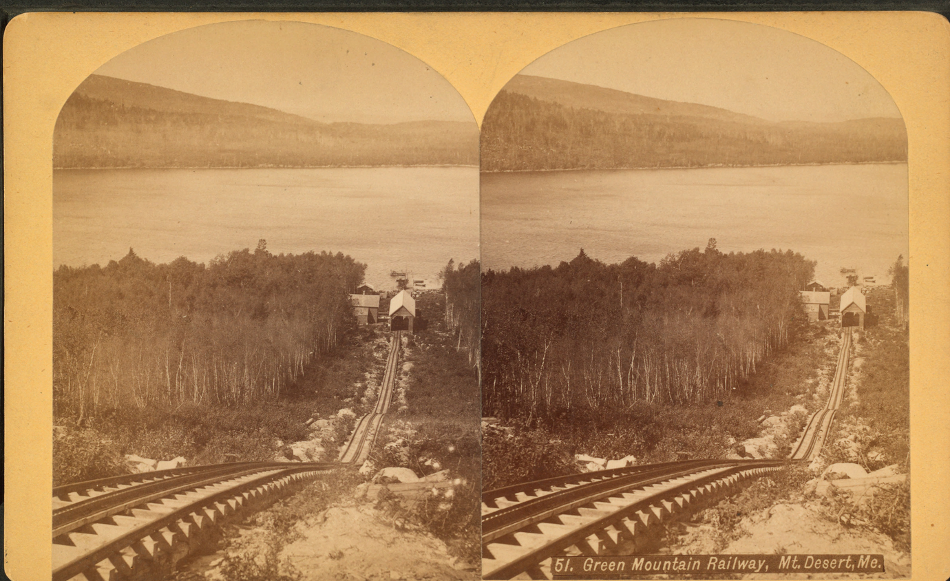
| Green Mountain Railway Cog Train, Bar Harbor, Maine |

NOTE; What I found most interesting about this newspaper story is the fact that the reporter did not have to guess at the number of people involved, he seems to have known the exact number involved, six men. This little war between the people who operated the Buckboard road up Green Mountain and the Green Mountain Railway company kept escalating to the point where much of the buckboard road was blown up, not sure if this account is of that or if this was prior to that. At one point wire gates were put up to block buckboards from going up the carriage road.


GREEN MOUNTAIN RAILWAY PHOTO ALBUM


 |
| RAIL BED ALONG GREEN MOUNTAIN RAILWAY ROUTE |


 |
| LAST REMAINING SECTION OF RAIL GREEN MOUNTAIN RAILWAY - ACADIA NATIONAL PARK |
 |
| $5,000 REWARD - GREEN MOUNTAIN RAILWAY ACADIA NATIONAL PARK |
 |
| RAILROAD SPIKES LEAD THE WAY GREEN MOUNTAIN - BAR HARBOR MAINE |

 |
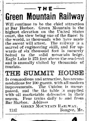
| SUMMIT HOUSE - GREEN MOUNTAIN BAR HARBOR, MAINE |
 |
| green mountain summit house |

 |
| FIRST TICKET SOLD GREEN MOUNTAIN RAILROAD BAR HARBOR MAINE |


 |
| AUGUST 17, 1883 GREEN MOUNTAIN RAILWAY TO ORDER SECOND LOCOMOTIVE |

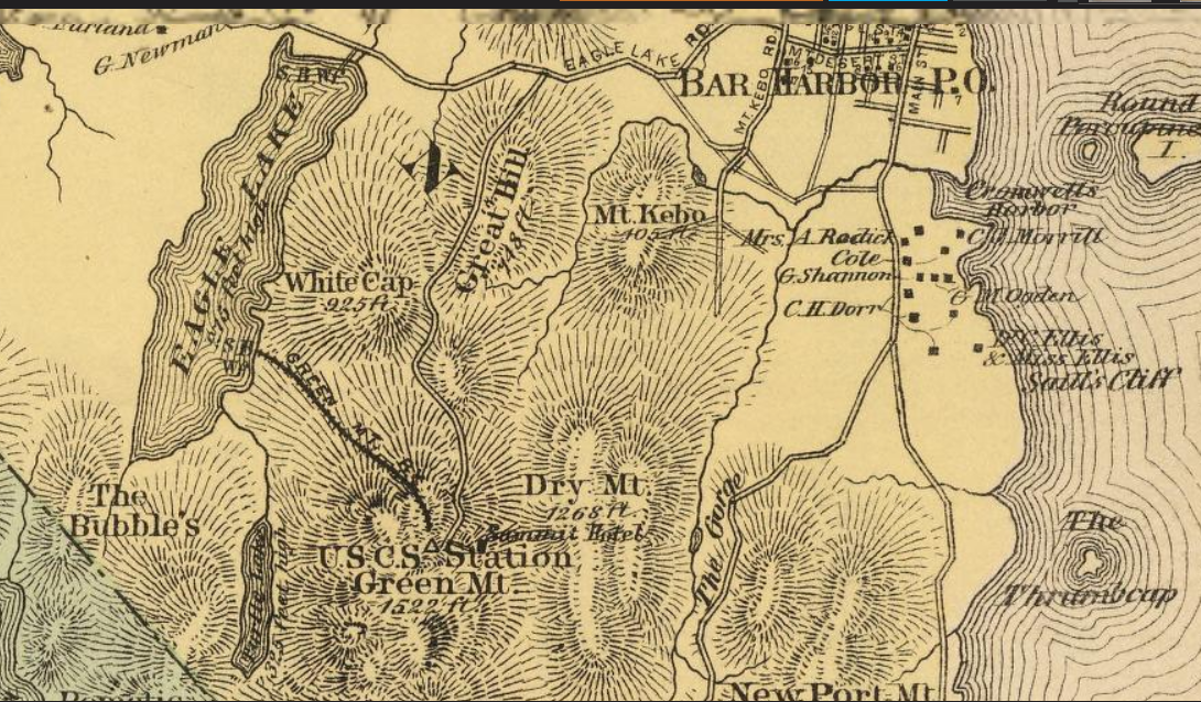
CADILLAC MOUNTAIN RAILWAY TRAIL
Today what is known as Cadillac Mountain was once called Green Mountain, and along one side of this mountain there once ran a cog train, this blog will help you locate and hike the route that train once took to the summit of what is today Cadillac Mountain in Acadia National Park.
The Green Mountain Railroad Trail is not, nor has it ever been an official hiking trail. Once the Green Mountain Railway Company went out of business, locals adopted the route the cog train followed as an unofficial hiking trail, and for a good number of years after that many sought to retrace the route the train once took on its daily trips from the shore of Eagle Lake to the summit of Green Mountain, renamed Cadillac Mountain years later.
As the years went by the route became more over-grown and fewer people hiked it and in time, only a few people knew the exact route the train once followed. Adding to the difficulty was a book which was published which gave out the wrong instructions to the site. The author of that book simply made a mistake and directed readers to the wrong pull over.
I assume anyone wanting to hike the route may want to start at the beginning, so I will start off with where the train tracks began by the shore of the lake.
 |
| CADILLAC MOUNTAIN (Green Mountain) ACADIA NATIONAL PARK |
I like to arrive at the general area by beginning at the Bubble Pond parking area, at the carriage road you will see a locked gage and the Park Loop Road beyond, cross the Park Loop Road and follow the Eagle Lake Carriage road until you come to an intersection, go right and follow it until you come to a wooden bridge with railings, this is your starting point.
Ahead and to the left you can see its pretty open with view of the lake, in that area is a thin stretch of land that goes outward onto the lake, that is where the main tracks began, an inward area to the left of that stretch of land is where another section of tracks ran to the water, and inbetween was a pier and buildings. I have not been able to find any railroad spikes in that area, but if you look at the map, you will see that thin strip of land was the starting point.
From their the train crossed the carriage road at an angle and went on to cross the brook which passes under that wooden bridge with the railings. In one account it clearly states "as the train started out, it crossed over a body of water," that being the brook. Where the train crossed the brook is a ledge that others have referred to as a small water fall, and indeed after a good rain water does rush down ofer it, the train crossed at a sharp angle in front of that small water fall, and now your journey begins.

 |
| LEDGE OR SMALL WATERFALL GREEN MOUNTAIN RAILROAD TRAIL - ACADIA NATIONAL PARK |
Just before the gully reaches the Park Loop Road, a worn path exits the gully and continues up toward the roadway, follow it to the small pullover straight ahead.
Now that you have hiked the lower section of the route the train took, and arrived at the small pull over, I will stop here to give instructions to anyone who wishes to simply hike the upper section. The instructions to the correct pull over are simple, if your driving along the Park Loop Road, you want to drive past the entrance to the Cadillac Mountain Summit Road and begin to look for a pull over up ahead on the right as your headed in the direction of Bubble Pond and Jordan Pond, that will be pull over number 1, continue past it and you will be going downhill, keep a sharp eye out for a tiny pull over on the right, easy to miss, park there.
If your coming from the other direction, you want to drive past Bubble Pond and round a sharp curve, and as your driving uphill look for the tiny pull over on the left, park there.
 |
| RAILROAD SPIKE - GREEN MOUNTAIN RAILROAD TRAIL ACADIA NATIONAL PARK |
Now your upper journey begins, looking directly across the road from about the center of that pull over you will see an opening in the woods, cross the road and walk up the banking, moving along the path to the left, there will be your first railroad spike, usually has one or two rocks by it. This is the point where many have trouble, at that spike, with your back towards the road, you want to walk straight ahead and upward through the woods, the ground looks a bit worn like maybe a dried out brook. The further ahead you go the more defined the trail gets. Sometimes you will see a few rock piles to help guide you. If you come to an area where the trail seems to stop, remember this rule, move straight ahead, and just beyond a tree or brush the trail appears again. I have not been to the area in some time, but a fellow hiker did tell me some one blazed the entire route, if that is true, it should be much easier to follow, however blazing or marking abandoned trails is illegal.
Not far ahead you come to the first real gem along the hike, a good section of built up railroad bed which once helped support the train tracks. This begins to follow a wall of rocks to the left before the route truns slightly and makes its way up through the woods again, but at this point you usually find more rock piles as well as those railroad spikes begin to show up, sticking 8 to 12 inches up out of the granite. It is worth noting that from this point forward you may run into some pretty slippery areas, as a nearby brook over flows its banks, making some areas of open granite very slippery.
 |
| built up section of rail bed |
From here onward the railroad spikes will pretty much lead you upward to that one last remaining section of rail which remains on the mountain side.
 |
| Green Mountain Railroad - Acadia National Park |
You will also begin to see small piles of rusting railroad spikes and many more spikes sticking up out of the granite. At some point the spikes stop and you are left following a worn path that suddenly ends at a thicker section of woods, remember the rule when the path seems to end, walk straight ahead, you will not have to go far before you come to a banking and the Cadillac Mountain Summit Road, to return back to the pull over follow the road downward to the left, when it comes to the Park Loop Road, go left and follow it to the second pull over.
If you want to go to the summit of Cadillac Mountain, go right upward,you don't have too far to go to reach it.
At this point you may be wondering, was this where the train tracks ended? No, they continued directly across the roadway, but there really isn't much more to follow and the brush and turran is a bit hostile to the arms and legs, so I always end the hike here, than relax on the summit before heading back, taking some nice photos of the setting sun as I go.
At some point I am going to do one more good walkthrough and take GPS numbers at any trouble spots and post those to serve as an additional guide.
The part of hiking this trail that amazes me to this day is as you hike along the route, even now you come to these tunnels through the trees where the cog train once passed along, and you can image the train still slowly making its way up the mountain side.
GREEN MOUNTAIN
RAILROAD TRAIL
(Lower Section)
Wooden Bridge by Lake
latitude 44 21' 32"N
longitude 68 14' 42"W
Shallow Gully begins
latitude 44 21' 33"N
longitude 68 14' 39"W
half way point
latitude 44 21' 33"N
longitude 68 14' 35"W
Pull Over
latitude 44 21' 33"N
longitude 68 14' 29"W

 |
| CADILLAC MOUNTAIN - GREEN MT RAILROAD TRAIL - ACADIA NATIONAL PARK |

 |
| The Green Mountain Railroad - Cadillac Mountain, Acadia National Park |
 |
| Green Mountain Railroad - Cadillac Mountain, Acadia National Park |
 |
| GREEN MOUNTAIN RAILWAY FORECLOSURE - Bar Harbor Maine |
VIDEO OF PATH THE TRAIN TOOK
FREE ABANDONED TRAILS OF ACADIA EBOOK - updated 2017
 |
| THE LOFT ANTIQUES 11 Holland Ave., Bar Harbor |
 |
| THE GATEWAY LOBSTER POUND Trenton, Maine |
 |
| THE TEA CUP INN Hulls Cove, Maine |
 |
| THE RODICK HOTEL Bar Harbor |
 |
| THE MOUNT DESERT NURSERIES Bar Harbor, Maine |
 |
| THE JORDAN POND HOUSE Seal Harbor, Maine |
 |
| THE KEBO SPRING WATER CO. Bar Harbor |
 |
| THE NEWPORT HOTEL Bar Harbor, Maine |
Subscribe to:
Posts (Atom)